Photo of multi-million Kenyan water project looks nothing like satellite images
This article is more than 5 years old
A photo on social media, shared to disprove a claim that President Uhuru Kenyatta’s government has neglected the central Kenya region, may come from India.
With the caption “Kiambu Urban Water Supply Project costing KSh530 million 100% complete”, the picture was posted on Twitter and Facebook.
A Google reverse image search shows that the photo has mainly been published in India.

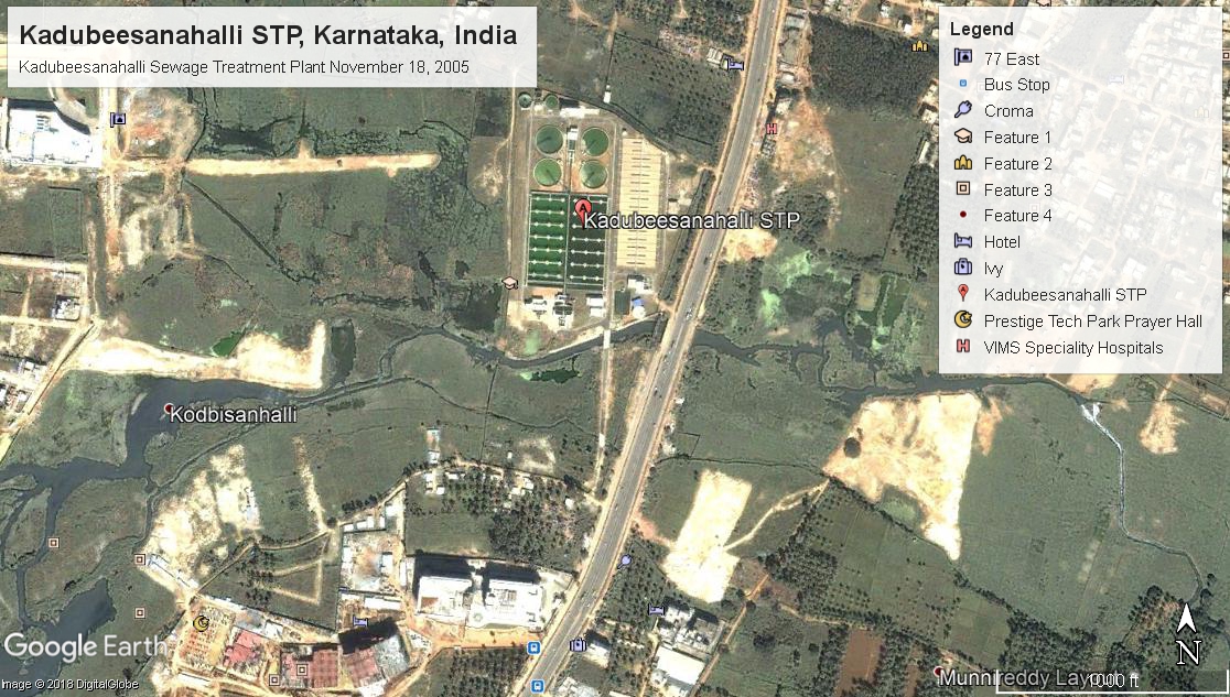
An Indian engineering company, Shapoorji Pallonji, lists on its website a sewage treatment plant in Bangalore, in the Indian state of Karnataka, as one of its construction projects. The plant looks a lot like the structure in the photo.
Africa Check reached out to Shapoorji Pallonji to ask if they had built the plant and if it was shown in the photo on social media. We will update this report should they get back to us.
A Google Earth satellite image from 2005, the year the Indian plant was completed, shows the homes next to the plant did not exist in 2005. In the social media photo, the buildings in the background appear to be under construction.
Kenya’s Presidential Delivery Unit lists the Kiambu Urban Water Supply Project as costing KSh540 million – close to the KSh530 million claimed in the image – and able to deliver 4,000 cubic litres of water a day.
Africa Check contacted the Athi Water Services Board, responsible for delivering water and overseeing water service providers in the counties of Nairobi, Kiambu and a small part of Muranga. The board referred us to its list of completed projects. (Note: After we published this check, the Athi water services board and the president's delivery unit both shared images of how the Kiambu project looks like. They are markedly different from the picture that has been circulating).
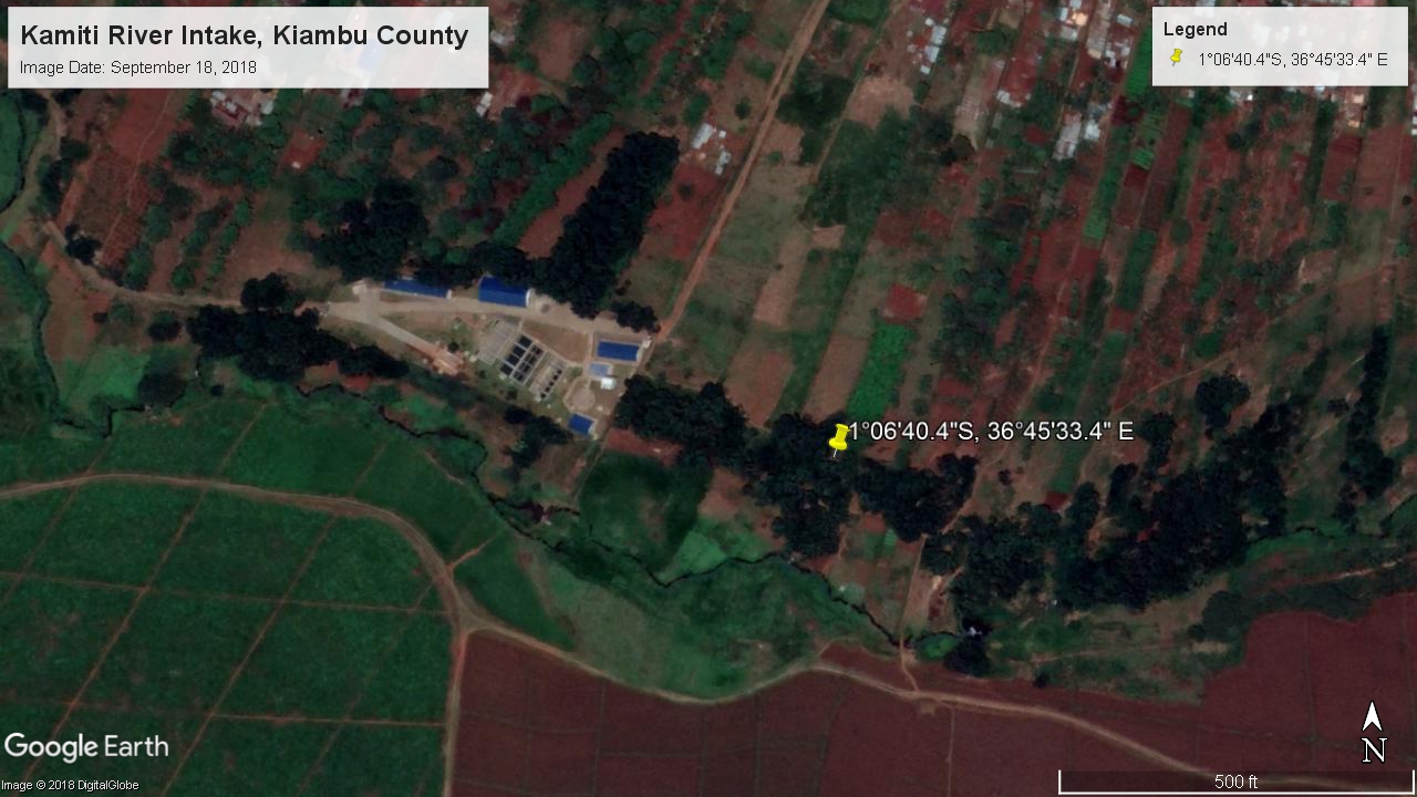
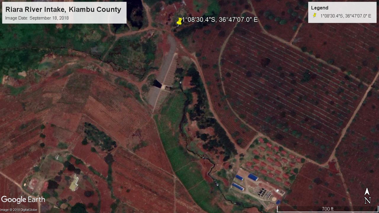
The project description says the Kiambu Urban Water Supply Project is now complete. The project has two parts: one on the Kamiti River, and a second on the Riara River.
We converted the two projects’ UTM location coordinates to latitude and longitude, using Montana State University’s geographic unit conversion tool.
The intake for the Kamiti water plant lies at latitude 1°06'40.4" south, and longitude 36°45'33.4" east. The Riara plant’s intake is at 1°08'30.4" south, and 36°47'7" east. Both are in Kiambu county.
Satellite images of these coordinates, taken in September 2018, show that the Kamiti and the Riara projects – the two parts Kiambu Urban Water Supply Project – don’t look anything like the structures shown in the social media photo. – Vincent N’gethe (01/02/19)
With the caption “Kiambu Urban Water Supply Project costing KSh530 million 100% complete”, the picture was posted on Twitter and Facebook.
A Google reverse image search shows that the photo has mainly been published in India.
An Indian engineering company, Shapoorji Pallonji, lists on its website a sewage treatment plant in Bangalore, in the Indian state of Karnataka, as one of its construction projects. The plant looks a lot like the structure in the photo.
Africa Check reached out to Shapoorji Pallonji to ask if they had built the plant and if it was shown in the photo on social media. We will update this report should they get back to us.
A Google Earth satellite image from 2005, the year the Indian plant was completed, shows the homes next to the plant did not exist in 2005. In the social media photo, the buildings in the background appear to be under construction.
A two-part water treatment project
Kenya’s Presidential Delivery Unit lists the Kiambu Urban Water Supply Project as costing KSh540 million – close to the KSh530 million claimed in the image – and able to deliver 4,000 cubic litres of water a day.
Africa Check contacted the Athi Water Services Board, responsible for delivering water and overseeing water service providers in the counties of Nairobi, Kiambu and a small part of Muranga. The board referred us to its list of completed projects. (Note: After we published this check, the Athi water services board and the president's delivery unit both shared images of how the Kiambu project looks like. They are markedly different from the picture that has been circulating).
The project description says the Kiambu Urban Water Supply Project is now complete. The project has two parts: one on the Kamiti River, and a second on the Riara River.
Finding the geographic coordinates
We converted the two projects’ UTM location coordinates to latitude and longitude, using Montana State University’s geographic unit conversion tool.
The intake for the Kamiti water plant lies at latitude 1°06'40.4" south, and longitude 36°45'33.4" east. The Riara plant’s intake is at 1°08'30.4" south, and 36°47'7" east. Both are in Kiambu county.
Satellite images of these coordinates, taken in September 2018, show that the Kamiti and the Riara projects – the two parts Kiambu Urban Water Supply Project – don’t look anything like the structures shown in the social media photo. – Vincent N’gethe (01/02/19)
Add new comment